Three permanent water quality monitoring stations are used to track water quality and are managed by the Guadalupe-Blanco River Authority (GBRA) through grant funding from the Texas State Soil & Water Conservation Board (TSSWCB).
Due to increased discharge from wastewater treatment plants, Plum Creek now flows year-round over most of its length. USGS gages at U.S. Highway 183 near Lockhart and at Caldwell County Road 131/Biggs Road near Luling monitor Plum Creek streamflows.
GBRA’s Water Quality Sampling & Data
Currently, routine ambient water quality data is collected monthly at 2 main stem stations by GBRA (#17406 and #12640) and quarterly at a third main stem station by the Texas Commission of Environmental Quality (TCEQ). The monitoring project, funded by US Environmental Protection Agency, through a grant from the Texas State Soil and Water Conservation Board (TSSWCB), will generate data of known and acceptable quality for surface water quality monitoring of main stem and tributary stations on Segment 1810, Plum Creek, for field, conventional, flow, bacteria and effluent parameters to support the development of a Watershed Protection Plan for the watershed. Monitoring includes:
- Routine ambient monitoring at 5 sites monthly, and one site quarterly over 15 months.
- Targeted monitoring at 35 sites twice per season, once under dry weather conditions and once under wet weather conditions each season, for four seasons.
- Automated stormflow monitoring at on urban/residential site during a minimum of four storm events.
- 24-hour dissolved oxygen monitoring at 8 sites monthly during the index period.
- Effluent monitoring of six wastewater treatment facilities, City of Lockhart plants(2), City of Luling, City of Buda, City of Kyle and Shadow Creek.
- Springflow monitoring at three springs.
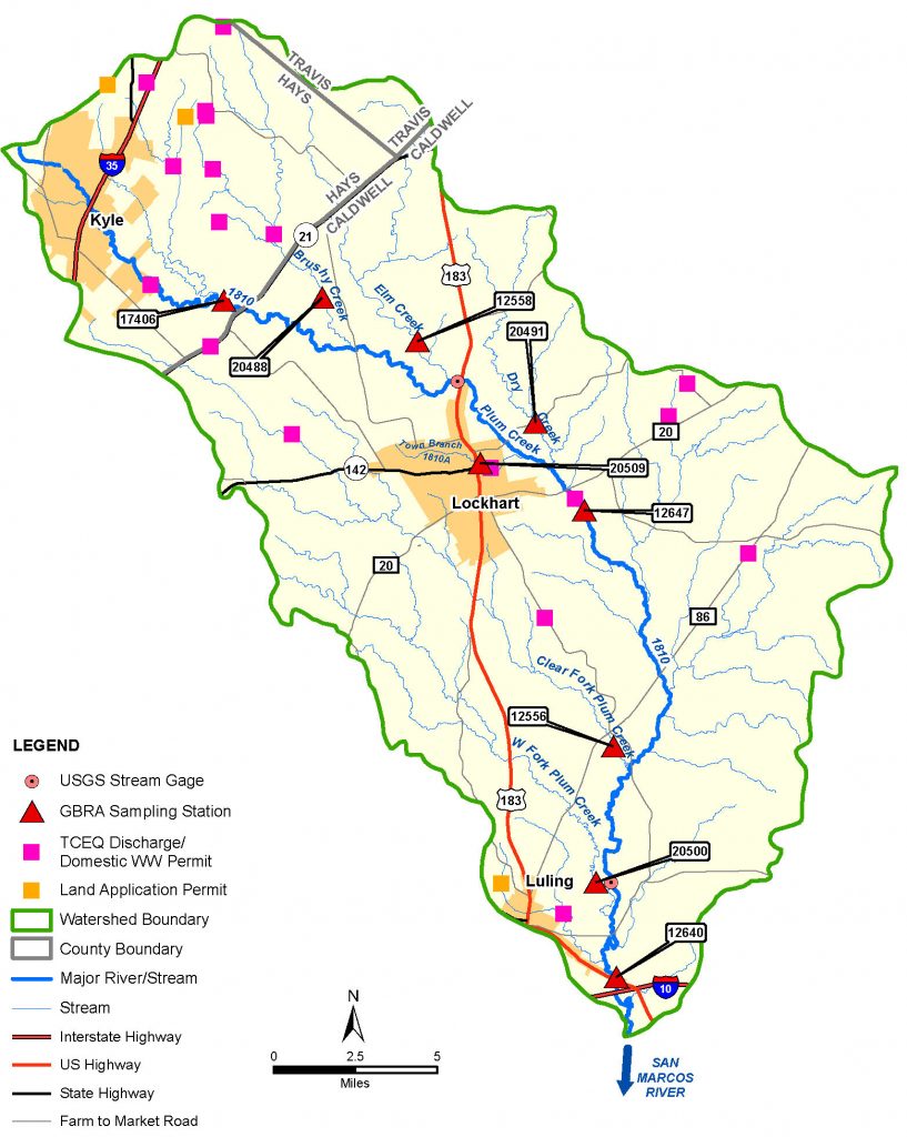
Plum Creek Watershed and GBRA Water Quality Monitoring Sites
(Updated October 2023)
Related Information
- Plum Creek Watershed Data Report (Texas Stream Team)
- Plum Creek Monitoring Project Plan (funded by TSSWCB)
- Water Quality Monitoring Project Quality Assurance Protection Plan
Map of Sampling Sites
Using the map below, click on a station to get information on the location and a link to the current data collected at the site.
List of Sampling Sites
Using the list below, click on a link in the Data column to get the current data collected at the site.
| Site No. | Site Name | Latitude | Longitude | Sample Type | Data to August 2020 | Data from September 2020 |
|---|---|---|---|---|---|---|
| 12538 | Andrews Branch at CR 131 | 30.03 | -97.827 | targeted | Excel | Excel |
| 12555 | Salt Branch at FM 1322 | 29.676 | -97.625 | targeted | Excel | Excel |
| 12556 | Clear Fork Plum Creek at Salt Flat Rd. (CR 128) | 29.76 | -97.602 | routine/diurnal | Excel | Excel |
| 12557 | Town Branch at E. Market St. (upstream of Lockhart WWTP #1) | 29.885 | -97.665 | targeted | Excel | Excel |
| 12558 | Elm Creek at CR 233 | 29.96 | -97.798 | routine/diurnal | Excel | Excel |
| 12559 | Porter Creek at Dairy Road | 29.974 | -97.812 | targeted | Excel | Excel |
| 12640 | Plum Creek at CR 135 | 29.657 | -97.602 | routine/diurnal | Excel | Excel |
| 12642 | Plum Creek at Biggs Road (CR131) | 29.7 | -97.604 | targeted | Excel | Excel |
| 12643 | Plum Creek at FM 1322 | 29.753 | -97.593 | targeted | Excel | Excel |
| 12645 | Plum Creek at Youngs Lane (CR 197) | 29.822 | -97.584 | targeted | Excel | Excel |
| 12647 | Plum Creek at Old McMahan Rd (CR202) | 29.865 | -97.615 | routine/diurnal | Excel | Excel |
| 12648 | Plum Creek at Old Kelly Road (CR 186) | 29.882 | -97.63 | targeted | Excel | Excel |
| 12649 | Plum Creek at CR 233 | 29.938 | -97.725 | targeted | Excel | Excel |
| 14945 | Clear Fork Plum Creek at Old Luling Rd (CR 213) | 29.826 | -97.668 | targeted | Excel | Excel |
| 16709 | Town Branch west of Lockhart | 29.826 | -97.668 | retired | Excel | – |
| 17406 | Plum Creek at Plum Creek Road | 29.96 | -97.798 | routine/diurnal | Excel | Excel |
| 18343 | Plum Creek upstream of US 183 | 29.923 | -97.679 | targeted | Excel | Excel |
| 20479 | Unnamed Tributary at FM 150 near Hawthorn Dr. | 30.003 | -97.887 | stormwater | Excel | Excel |
| 20480 | Plum Creek downstream of NRCS 1 spillway | 30.019 | -97.879 | targeted | Excel | Excel |
| 20481 | Bunton Branch at Heidenreich Lane | 29.971 | -97.819 | targeted | Excel | Excel |
| 20482 | Brushy Creek at FM 2001 (dwnstrm of NRCS 12) | 30.033 | -97.771 | targeted | Excel | Excel |
| 20483 | Elm Creek at SH 21 (downstream of NRCS 16) | 29.998 | -97.743 | retired | Excel | – |
| 20484 | Plum Creek at Heidenreich Lane (downstream of Kyle WWTP) | 29.963 | -97.831 | targeted | Excel | Excel |
| 20486 | 11041-002 City of Kyle WWTP | 29.97 | -97.832 | ww effluent | Excel | Excel |
| 20487 | Brushy Creek at SH 21 | 29.978 | -97.766 | targeted | Excel | Excel |
| 20488 | Brushy Creek at Rocky Road (Upstream of NRCS 14) | 29.961 | -97.748 | routine/diurnal | Excel | Excel |
| 20489 | Cowpen Creek at Schuelke Road | 29.981 | -97.712 | targeted | Excel | Excel |
| 20490 | Clear Fork Plum Creek at Farmers Road | 29.921 | -97.794 | targeted | Excel | Excel |
| 20491 | Dry Creek at FM 672 | 29.904 | -97.64 | routine/diurnal | Excel | Excel |
| 20492 | 10210-001 City of Lockhart WWTP #1 | 29.884 | -97.663 | ww effluent | Excel | Excel |
| 20493 | Clear Fork Plum Creek at PR 10 (State Park) | 29.853 | -97.697 | targeted | Excel | Excel |
| 20494 | 10210-002 City of Lockhart WWTP #2 | 29.872 | -97.622 | ww effluent | Excel | Excel |
| 20495 | Dry Creek at FM 713 | 29.858 | -97.58 | targeted | Excel | Excel |
| 20496 | Tenney Creek at Tenney Creek Road | 29.796 | -97.562 | targeted | Excel | Excel |
| 20497 | West Fork Plum Creek at FM 671 | 29.782 | -97.681 | targeted | Excel | Excel |
| 20498 | Copperas Creek at Tenney Creek Road (downstream of Cal-Maine) | 29.751 | -97.557 | targeted | Excel | Excel |
| 20499 | 10582-002 City of Luling WWTP | 29.685 | -97.627 | ww effluent | Excel | Excel |
| 20500 | West Fork Plum Creek at Biggs Road (CR131) | 29.7 | -97.612 | routine/diurnal | Excel | Excel |
| 20501 | Salt Branch at Salt Flat Road (Upstrm of Luling WWTP) | 29.687 | -97.64 | targeted | Excel | Excel |
| 20502 | Bunton Branch at Dacy Lane (upstream of NRCS 5) | 30.009 | -97.847 | targeted | Excel | Excel |
| 20503 | Plum Creek at Lehman Road | 29.991 | -97.858 | targeted | Excel | Excel |
| 20504 | Porter Creek at Quail Cove Road | 30.024 | -97.822 | retired | Excel | – |
| 20505 | Richmond Branch at Dacy Lane | 30.024 | -97.831 | targeted | Excel | Excel |
| 20507 | Clear Fork Springs at Borchert Loop (CR 108) | 29.869 | -97.731 | spring | Excel | Excel |
| 20508 | Boggy Creek Springs at Boggy Creek Road (CR 218) | 29.865 | -97.713 | spring | Excel | Excel |
| 20509 | Lockhart Springs | 29.887 | -97.668 | spring | Excel | Excel |
| 20510 | Hines Branch at Tenney Creek (CR 141, downstream of Cal-Maine) | 29.767 | -97.557 | retired | Excel | – |
| 99923 | 11060-001 City of Buda and GBRA WWTP | 30.057 | -97.836 | ww effluent | Excel | Excel |
| 99936 | 14431-001 GBRA Shadow Creek WWTP | 30.043 | -97.811 | ww effluent | Excel | Excel |
| 99937 | 14377-001 GBRA Sunfield WWTP | ww effluent | Excel | Excel |